 Live Music Archive
 Librivox Free Audio
 Metropolitan Museum
 Cleveland Museum of Art
 Internet Arcade
 Console Living Room
 Books to Borrow
 Open Library
 TV News
 Understanding 9/11
tv 9 News Now at 5am CBS September 30, 2010 5:00am-6:00am EDT
5:00 am

fredericksburg. about to move in to charles county and places in calvert, st. mary's, anne arundel especially have been hit very, very hard this morning. they have already had a couple of inches of rain. and we now have some new watches. before we go there, devon, maybe we can show the storm totals we have been watching since yesterday as these rain totals are piling up. this is one of the reasons we are talking about a threat of flooding. the flood watch is in affect. and you can see the green areas. fairfax county, woodbridge, stafford. those are two to three inch storm totals. four to six inch totals across parts of southern maryland down route 4 in to calvert and st. mary's county and even six inch totals across the northern neck. back to the weather computer. if we can, i want to show you the moisture streaming in from the south. low pressure coming out of south carolina already produced upwards of 20 inches of rain in eastern north carolina. obviously flooding is going on there. this will be with us for the
5:01 am
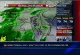
day. maybe lessening later in the afternoon. you can see how the moisture continues to stream north. look at those deep oranges. the deep tropical rich moisture moving north. with that and a storm tracking to this west. a tornado watch until 7 a.m. this is a short lived one. i imagine this will be replaced after 7 a.m. and basically everyone east of 95 including washington, much of howard county, eastern montgomery, down to the northern neck, southern maryland, eastern shore. tornado watch until 7 a.m. and as far as the flood watch, we have the flood watch until 9:00. the counties in green, which is the entire metro, southern maryland down to fredericksburg out to loudoun, eastern faulkier, prince william, manassas city, fairfax, that is a flood warning. through 9:00 p.m., a flood watch. the flood warnings go until 10:45 this morning. and as far as our rainfall projections potential any way through 1:00 this morning. we are still looking.
5:02 am
see those yellowish areas, that's eight to ten inches southern maryland through eastern virginia and the eastern shore. tremendous rains ahead. if you can stay home today do i. devon lucie is in with me and will join us later. right now we throw it over to angie goff. >> getting worse. >> yes. yes. >> let's talk about the tieups we have been tracking since early on. avoid the flooded roadways. proceed with caution. any intersections that you are approaching this morning. this is a big tieup we have been watching all morning. not this plea immediate area. 70 eastbound is closed between the river bridge and 29 columbia pike. traffic is being diverted on to columbia pike and from there the way to get around this until 8 a.m. so pretty much throughout the morning rush is to take 840 or 99. move it outside to 270. things are filling out early. a good amount of volume around germantown road an then we will see more delays than usual
5:03 am

given that heavy rain that we will be seeing throughout all morning. let's take you over to the maps again. chevy chase. this is another problem spot. a water main break. crews on the scene and willard avenue is closed between north park avenue and river road. you want to avoid the area. 66 filling out between 234 and 28. and then approaching route 50 and that is just volume. over to you. >> angie, thank you. we want to head out to a couple of crews in the field. they are giving you a closeup look at what you will experience if you leave in the next hour or so. kristin fish is live from leesburg, virginia. they are probably not thinking drought this time, are they, kristin? >> absolutely not. check out this incredibly spooky bridge i'm standing on. it is absolutely creepy out here. the things we do to bring you all the news. i'm telling you. we have been here all morning long. the rain is continuing to come down in a steady rate and right now this is the bridge at the
5:04 am

goose creek country club. and right over my shoulder, if we look down here, this is goose creek. you can see the water is really starting to churn down there. we are nowhere near the flood stage. flood stage is 12 feet an we are at 1.2 feet. the creek is expected to crest tomorrow morning at this time at 5.6 feet. we are nowhere near flood stage here but we are starting to see the water churn from the rain and they are going to be some concerns when you head to the lower-lying areas of loudoun county. if we pan up a bit you can see that just above the creek is route 7. this is the leesburg pike. this is the roadway we use to get out here this morning. and conditions were as good as can be expected but you can see how heavy this rain is falling right now. really coming down at a good rate and certainly makes for treacherous driving conditions this morning. i want to warn everybody who's watching, before you head in, to get started on the morning
5:05 am

commute this morning. you want to really watch out for those exit ramps, those shoulder roads. places where water really starts to accumulate. we hit some wet patches and this was two hours ago before all of this rain really had a chance to soak in on the ground. so it is going to be treacherous driving conditions this morning. we will be here all morning monitoring it for you. back to you. one place that knows even a little rain can lead to flooding is alexandria. especially in parts of old town along king street heading to the waterfront. that's where we find 9 news now reporter jessica doyle. good morning, jessica. >> good morning, andrea. since the last time we spoke it is really coming down cats and dogs. here. i'm standing in a puddle on king street where the street terminates at the waterfront and there's a lot of standing water accumulating at this point. i want to tell you a little bit what we are expecting for the potomac later today. we have a coastal flood watch
5:06 am

in affect all along the potomac, including the 20-block swath that always seems to get flooded in old town alexandria historically when we have major rain pattens moving in. i was at the waterfront a little while ago. it seems the water levels are pretty high. even though we are close to low tide. low tide is 8 a.m. this energy morning. high tide is what we really have to consider today. that is 1:00 p.m. at that point, as howard has been reporting, we have a lot of rain expected today. so there is really a risk of flooding today that folks need to be aware of. we have been showing you the drainpipe all morning long. we will walk over here. this will give you an idea how quickly the water is coming down. we really have not seen it pick up that much. it is definitely heavy rain, but it is not coming down in sheets we have seen bouts of that this morning, and i want to tell you about the drive in. definitely a lot of standing water out there as kristin fisher was talking about. you will be driving along and see a major puddle and you
5:07 am

don't know how deep it is. angie is saying don't drive through the puddles. another problem i found this morning when i was driving to work is i saw tree limbs down on the road. it is so dark with the cloud cover that you can't see this until you are upon it. so you want to keep the speed levels low. we will be watching the flooding conditions this morning and watching for sandbags. so far not a lot on them on the businesses here. now back to you in the studio. >> one place that knows even a little rain can lead to flooding is alexandria, but the bull's eye of the storm could be in annapolis, maryland. the city is under orders from the state to fix the 90-year- old water works dam which has been declared unsafe. but since those repairs have been started yet, officials have made changes to help the concrete structure hold through today's storm. >> we are taking a number of precautions. the first is we have lowered the level of the dam to 5.5 feet below the top.
5:08 am

there's no imminent threat of a major breakdown. >> reporter: the good news is the valley below the dam is virtually uninhabited. so there would be little immediate danger if it falls. some dc residents have a little added protection against whatever today brings. public works employees handed out sandbags to people who wanted to buffier their homes. the department is reminding people to remove outside furniture that could get blown around. don't forget to e-mail your pictures. send them to photos at wusa9.com. or post them on our facebook fan page at facebook.com/wusa 9. and if you are on twitter, hash tag your sweets with dc flood. we will return with other news after this break including the latest on yesterday's tragic bus accident that claimed a life and caused many commuters to have a very long commute. also, doctors decide to keep jimmy carter in the

5:10 am

good morning. welcome back to 9 news now. the fly over to the ramp from i- 270 remains -- is now open. this after the deadly bus accident yesterday afternoon that gnarled rush hour traffic for hours. a tour bus, heading back to pennsylvania from the national zoo, plunged off the ramp. the crash happened just after 4:00 p.m. >> the crash team investigators do not believe this vehicle was airborne. so it was not a 45-foot drop through the air. they believe the vehicle was in contact with the ground think entire trip down the embankment. >> reporter: the bus driver, 66- year-old joseph claybaugh was killed. 12 passengers including four children were injured. most take on the suburban
5:11 am

hospital in bethesda. all are expected to recover. two cars collide when the bus wrecked in front of them injuring one person. the ntsb has announced its team of investigators will look in to the cause of the bus crash. investigators have termed the deadly fire in northwest washington as suspicious. flames ripped through thing a- story apartment building on the 31 east block. two men jumped but one missed and fell to the grown. he later died. those who made it out safely so no fire alarms sounded. they only knew to escape because of neighbor's screams. former president carter did not make his book signing in dc last night. he's still in a cleveland hospital. doctors now believe a viral infection caused his discomfort. he was hospitalized on tuesday after suffering an upset stomach on a flight from atlanta to cleveland.
5:12 am

president carter turns 86 tomorrow. while we are starting to count how many inches of rain we will get, the totals are already approaching a foot in some places to our south. it is 5:12. here's howard. we have flood warnings, a tornado watch and torrential rains and i will let you know what the totals will get up to and how long it will last and what the weekend is looking like. 9 news now will return in just a moment. fresh chicken breasts. they're individually wrapped, so you can cook what you need and store what you don't. [ male announcer ] perdue perfect portions. ready when you are.
5:13 am

capital one bank. they're everywhere. yeah, you're right! ♪ [ male announcer ] capital one banks are everywhere. [ clang! ] with hundreds of branches and atms, they're hard to miss. hey, there's one right up the street. [ male announcer ] capital one bank. the most branches and atms in the dc area. what's in your wallet? ove, go long!
5:14 am

what's in your wallet? i do 22 more inspections than the government requires. and my fresh, all-natural chickens are never given any hormones or steroids. ♪ ...and no candy, gladys. [ clucks ] [ male announcer ] perdue.
5:15 am

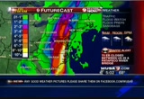
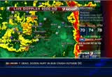
extra inspections... extraordinary chicken. some parts of carolina have reported over 20 inches. some roads are closed and one mobile home park has been evacuated. welcome back to 9 news now. howard bernstein was giving me that update and he has updates on what we are experiencing now. >> this is rapidly changing situation with the warnings and watches coming out. trying to travel today will be difficult. you are really taking a chance if you go out in the next six hours. southeastern virginia, eastern north carolina wait, please wait. do yourself a favor. start with live doppler 9000 hd because it is lit up big time. a lot of green, yellow. the orange and red, we are talking torrential rain, one to two inches an hour. maybe more than that in the heavy heavy downpours. start by zooming in to the
5:16 am
metro. we have had heavy rain move in the last 20 to 30 minutes. causing some folks -- the satellites are fading. we are hearing about that. bethesda, the rain is moving up wisconsin avenue. other areas to the south, south of lorton now we have heavy rain. also coming in from virginia. moving northward in to fairfax countiful travel will be tough just about anywhere. light to moderate rains in prince georges county. expand out and show you the heavy rains from annapolis down to western anne arundel in to calvert county and just in to the bay, in the northern neck. and this area of rain, we are talking about rain totals here have been incredible. this has difficulted to the bay as it is moving to the north. so far three to four inches of rain or more. upwards of five in to southern st. mary's county. kristin said the trampoline is gone and the winds. we had big winds and storms that rolled in earlier.
5:17 am

and this is just the beginning. a lot of light to moderate rain covering everybody but the yellow and oranges are the heaviest in the metro and.s south. on the weather computer, we will give you the tour. the moisture continues to stream in from the bahamas up here through north central, eastern north carolina. most of virginia, maryland, up through pennsylvania, new york now. it is really coming down. see the red box there? i will talk about that in a second. first of all, though, we have a flash flood watch through 9:00. metro montgomery, fairfax, dc, prince georges, parts of howard county in to loudoun and fairfax and prince william, southern maryland down to fredericksburg, flash flood warning until 1 on which 45 an the eastern sections, dc east, a tornado watch until 1:00 p.m. a lot of warnings from eastern north carolina and southeastern virginia. we have had isolated warnings earlier across southern maryland. that's a problem, too, this morning. heavy rain out there. the momslikeme.com bus stop
5:18 am

forecast, 59 to 73. today, rain and thunderstorms mid to upper 70s. maybe a little bit less action here late this afternoon. tonight, rain will taper to showers. breezy. 56 to 64. northwest winds 10 to 20. and then tomorrow, maybe some early showers east. otherwise partly sunny and highs near 75. 77 in cambridge. the warm air is streaming in from the atlantic coming up the bay. still around 60 in the shenandoah valley. we sit at 70-degrees in washington with the heavy rain. humidity is 94% and still a northeast wind where 77 cambridge. their winds are from the southeast and the moisture continues to stream up. look at this, right in there from the atlantic. meteorologist devon lucie has been with me all morning. he's in the web center. >> if you log on to wusa9.com. the first thing you are going to see when you log on is our interactive radar. on the main screen, you can zoom in and move the radar how you want to see it. or if you click on interactive radar it will give you a bigger
5:19 am

version of that. i want to tell you about the storm reports. if you click on storm reports under the weather tab, see that there, it brings the storm report here. tell me how much rain you have gotten. it gets in to the local in box and i can check it out and get it to you. and facebook, twitter we are getting you on there and the latest information on the web here. >> the storm reports are a great help. log on to wusa9.com and tell us what is happening for you. as we get to our seven-day forecast, obviously the concern is the next 12 to 18 hours. there will be problems. winds at times gusting over 30 miles an hour. widespread flooding. 74 with an early shower east tomorrow. saturday and sunday maybe a passing shower now and fall like with highs in the lower 60s. it is 5:20. flooding is getting worse, angie. >> we have some spots closing some roads early on. remember that wusa9.com going to be the one-top-shop for all
5:20 am

of that on our home page. we are tracking the tieups all morning long. just click on the black and yellow banner. this is one of the big tieups we have been following since early on. tractor-trailer is over turned on 70 eastbound. all lanes remain closed. we know traffic is being diverted on to 29 and from there hop on 40 or 99 to get around it and you want to do that throughout the morning rush because it looks like they will be out there until 8 a.m. moving to 495, watching the volume pick up on the outer loop. a lot of spray out here. it's a messy drive from university to georgia already filling out. the inner loop before 270, i'm getting word of an accident reported out there. we also have flooding as howard had eluded to. beach drive we know is closed and this is near franklin. and the inner loop at telegraph, some better news this way. the accident is gone but looks
5:21 am

like it is a slower ride than usual due to the heavy rain. and that's a quick look at traffic. over to andrea. once today's weather even is over, many washingtonians will turn their attention to mcnabb and his return to philadelphia as a redskin. more on that coming up in sports. it is 5:21. let's see who's celebrating a birthday on this last day of the month.


5:24 am

welcome back. mcnabb is talking about his feelings as he heads to philadelphia this week. he spent 11 seasons with them. many people are asking whether he will play extra hard in hopes of showing his old team he still has it. >> every player has a chip on their shoulder about something. is this something that i use?
5:25 am

maybe just an added chip i guess. >> they will probably boo him. they boo everybody up there. >> reporter: some of his teammates don't expect he will get a warm welcome from the philadelphia crowd but mcnabb says he thinks he will be cheered. the redskins take on philadelphia on sunday at 4:15. the nationals have played the last home game of the season. a bad outing for debt wilier. he gave up four homers and seven earned runs to the phillies. the nationals lose 7-1 but finish with a winning record of 41-39. they play three games in new york this weekend to close out the season. there's good news for the federal workers an washington. the threat of a possible government shutdown has been averted. the story is coming up. this is what we are watching throughout the morning. doppler radar to check on the heaviest rain and new storm warnings. what's happening on the roadways? traffic alert.
5:26 am

95 in virginia heading southbound at 123 we have an accident taking away two left lanes. more traffic and weather together when 9 news now returns.


5:29 am

welcome back to 9 news now. i'm andrea roane. thanks for joining us this thursday morning. angie goff will have the traffic in a moment. you had a problem along route 123 this morning. >> yes. 95, 70 we have problems. >> you got it and it is all because of howard's forecast and he's here, along with devon lucie. >> blame it on howard. >> blame me if it makes you feel better. >> you were very confident. >> yesterday i said the morning rush would be a disaster. so, yeah, i think so. it is turning out that way. we have had rainfall rates of one to three inches an hour and some of the totals in excess of
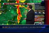
5:30 am

one to two inches an hour in some areas. that's why we are flood warnings now. this is because of tropical moisture. what's left of nicole, which was once a tropical storm has transitioned to low pressure. you can see it coming up the coast through south carolina and north carolina. the low pressure is spinning right now. intense rains across the carolinas, 20 inches plus down there. we are seeing totals in excess of four to five inches in the northern neck and the heavy rains are here and they are here to stay at least through the morning. maybe in to parts of the afternoon, as well. a tornado watch is also up until 1:00 p.m. misstated that earlier. it is 1:00 p.m. for most areas eastern shore, delaware and the northern neck to southeastern virginia. go to live doppler 9000 hd. show you what is happening. we have a couple of areas of intense rain. one on the bay moving to the eastern shore. that one likely has some winds gusting 80 miles an hour, maybe
5:31 am
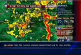
more with that. and torrential rains. you can see that here. it is just coming in across the bay. the bay bridge is a tough ride for anyone considering that. tough ride down 95 and out 66. zoom if to that area from washington south and west. you see the heavy rains that are moving up through parts of northern virginia from quantico to woodbridge, springfield over to fairfax, and burke, annandale, those places are being pounded by torrential rain right now. the heavy stuff is getting ready to cross 66. you see the green areas that are to the woodbridge, quantico? we are talking rainfall rates in the last hour to an inch just in the last hour. one more thing i want to show you before we go. go to the weather computer. because of the heavy rain we have a flash flood warning. entire metro, southern maryland until 10:45 and flood watch until 9:00 p.m. devon and i will be back at 4:45. right now let's get to traffic. >> i can't emphasize enough to
5:32 am

give yourself extra distance when you are braking. it is slick out there. there's a lot offering and standing water. we have to be careful. 70 eastbound right now. this is a tractor-trailer accident. it has all eastbound lanes closed. traffic is diverted on to 29. that's actually exit 87. from there you can hop on 40 or 9 as the alternate to get around it, which is what you will have to do because officials are telling us it will probably be out there until at least 8:00 this morning. on the inner loop approaching the spur, more problems. an accident is taking away a couple of rite lanes and we know the drivers are stacking up at river road. on the outer loop, north of this district looks like the main congestion is between university and georgia avenue. 66, hello, virginia. a slow ride and it's building between 50 and 123. going to want to watch the spray and the speeds. southbound on 95 at 123, more
5:33 am

crash activity causes drivers to lose a couple of left lanes. slow going approaching the prince william parkway to 123. andrea, over to you. it is 5:33. we want to give you a ground level view of the rainfall. kristin fisher is live in leesburg, virginia. where it might be a case of too much rain and too late for farmers who endured the drought conditions earlier this summer. >> absolutely. for the farmers they wanted to see this rain and they are sure seeing it now but as you said it probably is coming a bit too late. but for drivers and for people who are just waking up and getting ready to head in to work and get their kids to school, i have to say the rain will be a bit more of a nuisance than anything else. aside from the fact your lawn will look greener after the rain finishes falling. i want to give you a clothing report as you get up and start to get ready. i'm in full on gortex.
5:34 am

head to toe. and underneath i'm pretty dry. but i'm damp. i'm soaking wet. i stand outside five minutes before i see you live every half hour and within those five minutes i'm soaked. how many people wear gortex to work unless you are a reporter or you work in construction most people don't do that. so you are certainly going to want to wear heavy rain gear, bring your umbrellas and goloshs. wear as much rain gear as you have this morning and bundle the kids up if they are taking a bus to school this morning. one more thing to show you. this is goose creek in loudoun county, just outside of leesburg. you can see the water down there. it is really turning with all the rain coming down. every half hour we come out here it is getting more and more intense. but no threat of imminent flooding whatsoever. and if we pan up you can see right up here, this is the
5:35 am

leesburg pike. traffic is moving smoothly right now. that's good to see but it is certainly -- drivers going a little slower than normal because of the roadways that are very treacherous. you want to watch for that as we head to the heart of the morning rush. back to you. >> thank you, kristin. now one place we almost always see sandbags when there is a threat of serious rain is alexandria, virginia. businesses along king street in old town are so close to the waterfront, they are often the first to flood. 9 news now reporter jessica doyle is live from the front water with an update. also in head to toe gortex. >> that's right. it is a good day to have water proof jacket and pants on. that noise that you are hearing to my right here is actually a street cleaning crew. i'm going to step out of the way. so, as you can see it is business as usual to a certain extent here in old town alexandria. let's take it down king street for you. you can see the scene here. of course the street cleaning
5:36 am

truck moving out of the way. down the street at king and lee street in old town alexandria, folks in this neighborhood can go and get sandbags today. now you have to show up with a proof of residencecy. you can go ahead and get sandbags and treat the area around your home, sandbag the area around your home. we have video we want to show you right now. the control room can roll that and this is video of the crews out yesterday getting ready for these, this rain prep. they were out cleaning the gutters, getting ready for this. obviouslileting folks know the rain was coming and letting folks know the sandbags are available. we have seen many different types of rain here this morning. we have seen it coming down in sheets. we have a lighter rain falling at this time and i can tell you we have seen a lot of puddles accumulate. if you are out and about today you want to be aware of the situation. i'm here at my thai. this is a thai restaurant in
5:37 am

old town. there are no sandbags here. this entire portion of king street not one business has sandbagged so far and i hope we can take it as a good sign of things to come. >> thank you. we will be here with you throughout the morning. but when you can't be near the television you know you can log on to our website at wusa9.com. we will keep you up to date with storm totals and forecasts. and plus you can check the current dollar radar on our home page. good news for thousands of nasa workers. that story is coming up. plus, the fbi gets a better idea of how much damage the times square bomb could have done. angie, what's happening now? >> we are taking a live look at 95 heading -- or 495 at river road where drivers are starting to stack up on the inner loop as they approach the spur. we will have more headlines next. stay with 9 news now.

5:39 am

the fbi tested a device similar to the one tried to be used in times square. the test is part of the evidence the judge will consider in sentencing the man next week. with only a couple of shuttle missions left on nasa's schedule the house voted last night to extend the life of the space shuttle program. the bill also dismantles
5:40 am

president bush's plan to return astronauts to the moon but backs president obama's wish to use commercial carriers to lift humans in to near earth space. on captiol hill overnight, the senate and house passed a temporary spending measure needed to keep federal agencies operating tomorrow when the new budget year starts. most lawmakers are heading to campaign in their home districts without holding a vote on extending the bush era tax cuts. breaking news to report. one of hollywood's biggest stars and most loved entertainers, tony curtis has died. he was 85 years old. we will have more coming up when our news continues. when we come back, the driving is getting trickier and some of us may start to wish we had some sandbags handy as this day of rain goes on. it is 5:45. here's howard on the terrace. on the weather terrace, umbrella and rain jacket in hand. it is pouring across much of the area. tornado watch, flood warnings.
5:41 am

live doppler 9000 hd it is all coming up with the forecast when 9 news now returns. [ son ] my parents have always lived in the states. until two years ago, when my dad transferred to istanbul. they settled in quickly. found their local deli. a few shortcuts. and a neighborhood hangout. but there's one thing they miss. their beloved hometown team. so i asked citi -- how many thankyou points it would take to give them something special. their old seats, 5 and 6, row c. [ male announcer ] citi thankyou points can be used for almost anything you choose. what's your story? citi can help you write it.


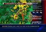
5:44 am

welcome back to 9 news now. >> rain is coming down in buckets. some areas are seeing near severe weather with strong wind. much of the action has moved to the eastern shore. move to live doppler 9000 hd and show you what is happening. a lot of heavy rain across the region. here in townen and also to the east. this is where you are seeing it. we will zoom in to the metro and show you what is going on. we have a lot of water that's coming down now, which is really starting to pond up on area streets. here in washington, you see the greens. moderate rain and now those heavy rains west of town. fairfax county, out to prince william county, and northern
5:45 am
faulkier county up to the north, loudoun county south of woodbridge, quite a hefty storm and east of gaithersburg to the metro, shady grove metro or derwood ere you are seeing heavy rain. eastern shore. let's talk about that. that band of storms earlier was responsible for some doppler- indicated tornado warnings. no warnings on that at the moment. however, over to tillman island, i know lou anne is out there. she called me in. looks like you could be getting winds 30 to 40 miles an hour. this is lifting to the north. queenstown, the bay bridge. trying to cross that. it is really tough driving. this band is putting down some rainfall rates two to three inches an hour and we have seen that. these are the one-hour totals that are showing now here across the bay. you can see some of these totals. two inches, an inch and three quarters. so you have torrential rains right here on the bay, moving to the eastern shore. go back to doppler and move south. i want to talk about what is happening in southern maryland,
5:46 am
as well, because there's been moderate to heavy rainfall. st. mary's and calvert county and you can see it leonardtown to st. mary's city. east of new land we have some of that and it is lifting to the north. back to the weather computer and show you what is happening here as the storm is really down, coming out of south carolina in to north carolina as the tropical plume of moisture continues on top of it. look at all the yellow. we are talking past roanoke to binghamton right now. not much on the immediate coast. however, coastal north carolina, down to the chesapeake, virginia beach area, numerous tornado warnings and you see the red line there. that is a tornado watch. and that covers much of the area from the metro east until 1:00. the flash flood warnings have been posted for the entire metro up to loudoun, eastern faulkier, prince william,
5:47 am

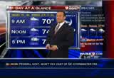
montgomery, prince georges, southern maryland, down even to king george county in forburg until 10:45 this morning and you saw all of the heavy rain that has been falling over the last few hours and will continue to do so. at least through 10:45. then we will see where other flood warnings will be needed because it is piling up at north beach and chesapeake beach. reports of flooded roads that way as well and as we said a tornado watch in affect and in to fairfax, prince william,.s east, including dc until 1:00 this afternoon. land falling tropical systems and this is a pseudo system from the right side of the track you always have a tornadic threat. the momslikeme.com bus stop forecast, i have been driving my kids to school and keeping them home on a day like today. heavy rain in many many areas. our sun is up at 7:03. today at a glance, we have rain, heavy at times. some thunder heavy at times. highs in the upper 70s.
5:48 am
push 80 or low 80s south and east of town where the warm air moves in an the winds will turn east to south at ten to 2 a miles an hour -- 20 miles an hour, at times gusting to 30. and a better looking day tomorrow after some early showers east. partly sunny and highs near 75. meteorologist devon lucie is with me all morning. he's venturing outside right now. devon? >> i want to show you how much the rain is coming down right now. the wave of heaviest rain just moved through. on the weather terrace we are looking at steadier rain that moved through. heading out to school or at home you can help us big time. set up your rain gauge. usually sammy snow stick is checking out the snow but if you have a high vase or something like that it will tell you how much rain is falling at your place. speak of that, you can log on to wusa9.com and that's the main page. that's our interactive radar.
5:49 am

one tool to help you check that out and also you can check on the storm reports. it's under the web tab go. and send in and tell us how much rain has come at your house by using one of these. going to school today, science clasp one of the fun things you can do to help track the rain throughout the day. >> looking at interesting things when we look back -- nice to see sammy snow stick -- front is back here. the 70s in the south and east. and winds are northernly but the southeast winds will kick and the warm air will surge toward us. 70 degrees. 68 on the dew. humidity 94% and the northeast wind at six. we are watching the storm. it is coming up from the south. it will take a good portion of the morning in though afternoon. perhaps this afternoon, things settle down a bit. but the next six hours will be rough and potentially dangerous to be out with flood warnings expanding across the region.
5:50 am

78 today. windy. heavy rain. potentially strong or tornadic thunderstorms, as well. the tornado watch until 1:00. better by the weekend. saturday 70. sunday cool and low 60s with a chance of a shower. it is ten before 6:00 on this wet thursday. all right. got a lot of traffic issues going on, as you would expect. and we want to begin with our beltway alert. on the inner loop approaching old georgetown road is where we have an accident only letting one lane of traffic squeeze by using the left shoulder. as a result, we are watching a delay around the river road exit continue to build. on the outer loop we are incident free and below speed from university and georgia avenue. take it over to 270 where we are getting word of a disabled vehicle. this is approaching route 48 and it's taking away a left lane. in the main congestion is stretching from germantown road to montross. moving next to the the district. inbound new york avenue, no incidents out here but drivers are using the brakes between
5:51 am

the times building to bladensburg road. in the district, a reminder to watch for flooding spots and approach intersections slow. let's take it to virginia's 395, crawling early from the beltway over to seminary. plus ten minutes for that and good news. we wrap it up with 95 southbound at 123. the accident is clear, but you are stop and go heading northbound making your way from the prince william parkway to newington. andrea, over to you. today is the last day for some tax laws in our area to come clean without penalty. that story is coming up. plus, an investigation in to despicable charges leveled against employees at a local nursing home. the time is 5:52. 69 very wet degrees. we'll be right back.
5:52 am

my dad is the supervisor of a train station and my mom's a teacher. my dad's an auto technician. my mom's a receptionist. i'm not sure i would have been able to afford college without the tuition freeze. while tuition in other states is rising out of reach... governor o'malley made the tough choice to freeze tuition. he made my dream of going to college into a reality. i'm the first in my family to go to college. my brother and i never would have been able to afford college. even though times were tough... governor o'malley kept his promise. there's never a doubt... there's never a doubt whose side he's on. martin o'malley... moving maryland forward.

5:54 am

welcome back to 9 news now. the endorsements for o'malley have started to roll in. while this afternoon michael bloomberg an independent will endorse o'malley at an event in bethesda. his republican challenger, former governor ehrlich is
5:55 am

getting big apple support of his own. he has been endorse by rudy giuliani. president obama stopped in richmond, virginia on thursday before returning to the white house. he spoke to a small group of people and speculated that the republicans made a strategy of trying not to work with the white house since he took office office. sorry we're having problems with the audio but the president told his audience he believes republicans thought the white house would get credit for any successes on bipartisan bills, and that would reduce their chances of winning backseats in november's mid-term elections. today is the last day for dc residents take advantage of the city's tax amnesty program. delinquent taxpayers who settle up today will avoid collection fees, penalties and possible prosecution. otherwise they say delinquent individuals should expect additional money to be withheld from their paychecks starting in january.
5:56 am

the tax and revenue customer service center will be open until midnight tonight. it is at 1101 4th street southwest, 270 west. a 22-year-old male day care worker is charged with sodomy. police say he sexually assaulted a 4-year-old girl on september 21st at the mini land day care center. police say he was caught in new york trying to flee to canada. he's now awaiting extradition to fairfax county. nearly a dozen employees at an arlington nursing home have been indicted and two already stricted. in one of the largest nursing home abuse cases in virginia history. as peggy fox reports the most serious charge involved a nurse who's accused of holding a pillow over an elderly man's face. >> my husband's diaper, the time the diaper was changed and i come in 12 hours lair and the
5:57 am

diaper was saturated and never changed. >> reporter: she said she complained constantly about the care her husband received during the last seven years of his life. >> the dentures were never removed from his mouth and cleaned. his fingernails and toenails were dirty and long. his hair never shampooed or shaved. >> jack evans with was partially paralyzed barely move and had trouble breathing. his widow said he would find his lunch uncovered and untouched in the evening. >> no one would feed him and he couldn't feed himself. it was dropped off there. sometimes there would be roaches on the tray. >> evans attorney says the medicaid fraud office asked if she would allow the fbi to putt a surveillance camera in her husband's room she said yes. >> with the evidence on the videotape, the commonwealth attorney was able to indict 11 employees on charges ranging from neglect and forgery to assault and battery. the worst case involved a male
5:58 am

nurse, who was caught on tape holding a pillow over mr. evans ' face. the nurse charged in the billow incident is 30-year-old john diaz his trial is coming up next month. this woman, a nurse's aide has already been convicted of assault. she is seen in a video laughing while she throws popcorn at mr. evans as he tries in vain to bat it away. >> my husband was scared to death. >> reporter: evans filed a $10 million lawsuit against potomac center, the holding company genesis health care and 35 other defendants. her attorney says these problems are rampant in for profit nursing homes. >> this is not one person, a rogue employee. this is the whole, virtually the medical staff there. >> they released a statement saying the resident if question received appropriate care during his stay and denies he was neglected at anytime. and potomac says it is committed to providing quality care and will continue to cooperate with the government's
5:59 am

investigation. in arlington, peggy fox, 9 news now. >> potomac says the two employees accused of assault have been terminated and the others charged with forgery and neglect have been placed on leave pending the outcome of their trials. we thank you for watching 9 news now at 6:00 a.m. howard bernstein is here. he's very busy and here with devon lucie. the forecast, rain rain and it won't go away anytime soon. >> no. heavy rains off and on through midday and the afternoon as term. we have flood warnings and a turn watch. tornado warnings to the south and east and through mid- morning things will get worse before they get better. we start with live doppler 9000 hd because we have a lot of rain to talk about. the heaviest band seems to be along the eastern shore. could be winds to 30 to 40 miles an hour. you can see it east of annapolis over to queenstown and down to west of easton and sane michaels and tillman, extending and the ban extends in to southern
203 Views
IN COLLECTIONS
WUSA (CBS) Television Archive
  Television Archive News Search Service
Uploaded by TV Archive on
